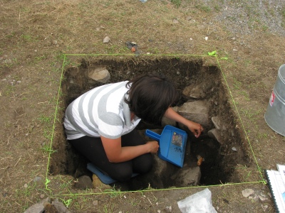
You may notice a flurry of posts lately about interpreting the layers of soil (or stratigraphy) at archaeological sites. That’s because we are finished with digging (as of today) and the students have spent time interpreting, mapping and photographing the stratigraphy of our excavation trenches. Here’s a great discussion of how the stratigraphy at the North Range Barracks site works.
Stratigraphy: the (study of) layers of sediment deposited over top of one another by natural or cultural processes. The ‘youngest’ layers are on top of the ‘oldest’ layers, unless someone has been messing about digging holes and the like. Interpreting stratigraphy was one of my loudest “I’m going to mess this up!” fears going into this field school.

Interpreting stratigraphy often involves crunching yourself into tiny places and staring at walls intently for long periods of time.
Stratigraphy is important after all. The layers of soil can tell you a great deal about the timing of major events. For example, at the North Range Barracks, there are two layers (aka strata) with a good chunk of rubble in them, one several layers above the other. The one closest to the surface is a WWII destruction layer from when the American military leveled the area to put in a a machine gun.
The lower one is significantly deeper (and therefore older) and is filled with brick, and mortar, as well as stone rubble, and lies just above the midden-like deposits that hold all those nifty mystery artefacts we’ve been showing you. Probably, this layer comes from renovations done to the building to convert is from barracks into storage circa 1842.
Now, if we just ignored the differences in strata, we’d miss the interesting information that there were renovations to the building at all when it was converted into storage. Even the less dramatic, non rubble-filled strata help create the story of the barracks site. We can see layers of old sod from where ground level used to be, for example.

How many students can fit in a 1-x-4 meter trench and contemplate stratigraphy? Eh, I think there was room for a few more...
So why was I frightened I’d mess this stratigraphy thing up? Well, they are subtle! The layers can just be very slightly different colours–I never knew how many shades of brown existed before this course. (Amanda notes: ah, the joys of using a Munsell chart– how many different ways can you describe ‘brown rocky soil’? Dozens, apparently… ). Strata can also ”feather’ into each other, making the transition gradual and hard to spot. Plus, sometimes they strata are only a centimeter thick – far too easy to miss them completely!
Luckily for me, the North Range Barracks site has beautiful stratigraphy (Amanda notes– you probably never thought you’d use the words ‘beautiful’ and ‘stratigraphy’ in the same sentence until taking the field school, did you?) . The layers are (relatively) clear and distinct, with significant colour changes and depth. I am even more thankful for this fact now that we
are mapping the profiles (the walls of the trenches) to showing the sequence of the strata!
So looks like I needn’t have worried… at least for now.
—Hannah Mallinson (Student)
Leave a comment